This project builds upon the spacially-explicit models developed at the ECHO laboratory in the past years. SIRB spatially-explicit models, where communities located at different nodes are linked considering both the hydrological and human mobility network, have produced accurate projections during the Haitian cholera epidemic, demonstrating the reliability of this method.
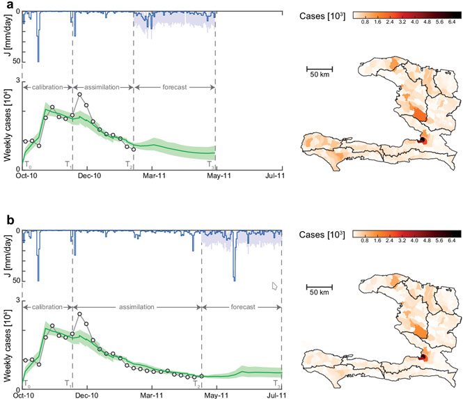
Example of two cholera forecasts for the Haitian outbreak as proposed Pasetto et al. [2016]. Comparison between the weekly cases recorded cases (circles) and the 90% confidence interval estimated by the model (light-green areas). Blue lines represent the average daily rainfall used as forcing in the cholera model, which is measured from T0 to T2 and forecast from T2 to T3 . Light blue areas show the 90% uncertainty associated to the forecast rainfall. Maps show the expected value of the forecast cumulative cases on each model sub-unit.
The figure above illustrates the capabilities of the spatially-explicit model developed at the laboratory of ecohydrology in reproducing and projecting the future evolution of the Haitian epidemics under possible rainfall scenarios. It uses a data assimilation method, enabling the use of new epidemiological data as it becomes available, and thus avoiding painful recalibration procedures.
Building on this operational epidemic forecasting, this project has three aims, detailed in the sections below.
Real-time forecasting and evaluation of intervention strategies in outbreak settings
First, we aim at developing a real-time forecasting tool for waterborne disease epidemic. It should encompass intervention campaigns, precipitations forecast and human mobility (from mobile-phone data or mobility models). The model should be updated using a data assimilation procedure each time new data becomes available.
The feasibility of a real-time forecasting system for cholera outbreak critically depends on the immediate implementation of a surveillance system and the release of the relevant epidemiological data. We rely on a close collaboration with governmental and non governmental organization in the field, especially with Médecin sans Frontière, in order to set up rapidly our model for new cholera outbreaks. The purpose is to give short and medium term predictions of cholera incidence in space and time to partners in the field.
Optimal control for intervention strategies
In addition to forecasting, we intent to use our framework to design optimal control strategies (and their practical recommendation counterparts), helping officials to rationally deploy available control measures (vaccination, mobility restrictions, sanitation, …). At the beginning of an outbreak, when peak values of infected individuals are recorded, the numerical solving of the nonlinear optimization problem is highly non-trivial.
Design of optimal surveillance plans
The last part of the project involves surveillance (i.e the collection and interpretation of health-related data needed for public health practice). The goal here is to answer the minimal essential data question, to optimize our capacity to reconstruct the internal state of the epidemic from some readily available observations. Then, we would be able to put to a better use available resources, through practical surveillance policies, to observe the current state of epidemics.
Operational foracast of the Haitian cholera epidemic after hurricane Matthew.
Reports produced in collaboration between Epicentre and the ECHO lab on modelling the dynamics of cholera in Haiti following the passage of Hurricane Matthew.
Prediction of cholera dynamics in Haiti following the passage of Hurricane Matthew
Benefit of vaccination in protecting the departments of Grand’Anse, Ouest and Sud against a potential second epidemic wave of cholera

Period : 2017-….
